La Porte night lights from space
Night Light of La Porte (Texas) from space (United States) Src. Average luminocity for 10x10km area is 77.8631% and for 50x50km: 59.6991%.
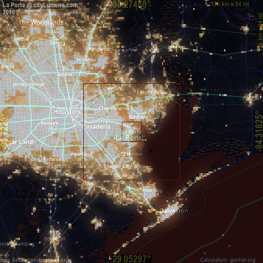

Analysis of La Porte night lights 2016
Square area 10x10 km:
 21.63%
90-99
22.42%80-89
9.13%70-79
7.54%60-69
12.5%50-59
15.28%40-49
6.94%30-39
3.57%20-29
0.99%10-19
0%0-9
0%Square area 50x50 km:
17.09%90-99
13.62%80-89
9.01%70-79
10.17%60-69
10.21%50-59
6.18%40-49
3.68%30-39
3.23%20-29
2.44%10-19
3.9%0-9
20.48%Clear (daylight) street map image can be seen on geolist.org.
Map coordinates:
30° 16' 29.6" North, 95° 43' 21" West
29° 39' 56.8" North, 95° 1' 9.7" West
29° 3' 10.7" North, 94° 18' 58.5" West
Some cities around La Porte sort by population:
• Pasadena
18.5 km =11.5 mi,  278°
278°
• Baytown
8.7 km =5.4 mi,  27°
27°
• Channelview
15.3 km =9.5 mi,  323°
323°
• Deer Park
11 km =6.8 mi,  293°
293°
• Seabrook
11.3 km =7 mi,  182°
182°
• Webster
17.1 km =10.6 mi,  213°
213°
• Bacliff
17.9 km =11.1 mi,  171°
171°
• Highlands
17.4 km =10.8 mi,  348°
348°
4704108 (p: 35,148)
Sources (retrieved 2019-11-25):
» Earth at Night: Flat Maps 2012, 2016