Dickinson night lights from space
Night Light of Dickinson (Texas) from space (United States) Src. Average luminocity for 10x10km area is 70.3409% and for 50x50km: 46.1918%.
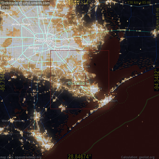
Analysis of Dickinson night lights 2016
Square area 10x10 km:
 6.44%
6.44%90-99
9.09%80-89
10.42%70-79
17.99%60-69
27.08%50-59
25%40-49
3.6%30-39
0.38%20-29
0%10-19
0%0-9
0%Square area 50x50 km:
9.86%90-99
9.33%80-89
6.94%70-79
8.2%60-69
6.29%50-59
6.69%40-49
5.38%30-39
5.37%20-29
6%10-19
8.48%0-9
27.47%Clear (daylight) street map image can be seen on geolist.org.
Map coordinates:
30° 4' 16.1" North, 95° 45' 16" West
29° 27' 38.8" North, 95° 3' 4.8" West
28° 50' 48.3" North, 94° 20' 53.5" West
Some cities around Dickinson sort by population:
• League City
6.7 km =4.2 mi,  320°
320°
• Friendswood
16.4 km =10.2 mi,  297°
297°
• La Marque
12.9 km =8 mi,  142°
142°
• Seabrook
11.8 km =7.3 mi,  12°
12°
• Santa Fe
10.6 km =6.6 mi,  209°
209°
• Webster
10.7 km =6.6 mi, 322°
• Bacliff
7.7 km =4.8 mi,  48°
48°
• Hitchcock
13 km =8.1 mi,  164°
164°
4686163 (p: 19,895)
Sources (retrieved 2019-11-25):
» Earth at Night: Flat Maps 2012, 2016