Waynesville night lights from space
Night Light of Waynesville (Missouri) from space (United States) Src. Average luminocity for 10x10km area is 27.0017% and for 50x50km: 4.3325%.
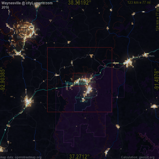
Analysis of Waynesville night lights 2016
Square area 10x10 km:
 1.87%
1.87%90-99
4.76%80-89
1.87%70-79
3.57%60-69
3.4%50-59
3.23%40-49
5.78%30-39
5.61%20-29
7.82%10-19
29.08%0-9
32.99%Square area 50x50 km:
0.35%90-99
0.57%80-89
0.4%70-79
0.47%60-69
0.56%50-59
0.65%40-49
0.65%30-39
1.2%20-29
1.32%10-19
3.81%0-9
90%Clear (daylight) street map image can be seen on geolist.org.
Map coordinates:
38° 22' 54.9" North, 92° 54' 13.9" West
37° 49' 43.1" North, 92° 12' 2.6" West
37° 16' 16.3" North, 91° 29' 51.4" West
Some cities around Waynesville sort by population:
• Jefferson City
83.2 km =51.7 mi,  1°
1°
• Rolla
40.1 km =24.9 mi,  70°
70°
• Fort Leonard Wood
14.2 km =8.8 mi,  164°
164°
• Lebanon
43.9 km =27.3 mi,  247°
247°
• Fulton
115.3 km =71.6 mi,  11°
11°
• Bolivar
109 km =67.7 mi,  257°
257°
• Marshfield
82.7 km =51.4 mi,  228°
228°
• Sullivan
100.4 km =62.4 mi, 65°
4413802 (p: 5,374)
Sources (retrieved 2019-11-25):
» Earth at Night: Flat Maps 2012, 2016