Bolivar night lights from space
Night Light of Bolivar (Missouri) from space (United States) Src. Average luminocity for 10x10km area is 24.3776% and for 50x50km: 1.6202%.
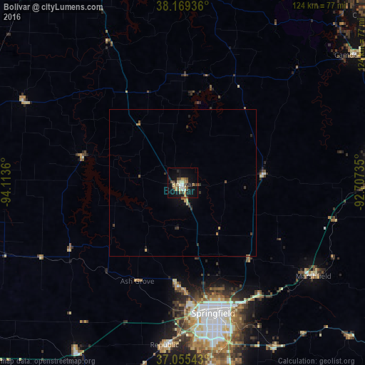
Analysis of Bolivar night lights 2016
Square area 10x10 km:
 1.53%
1.53%90-99
3.4%80-89
4.93%70-79
2.89%60-69
3.23%50-59
4.25%40-49
3.91%30-39
1.36%20-29
3.4%10-19
25.34%0-9
45.75%Square area 50x50 km:
0.06%90-99
0.16%80-89
0.25%70-79
0.3%60-69
0.23%50-59
0.23%40-49
0.23%30-39
0.34%20-29
0.21%10-19
1.33%0-9
96.65%Clear (daylight) street map image can be seen on geolist.org.
Map coordinates:
38° 10' 9.7" North, 94° 6' 49" West
37° 36' 52.1" North, 93° 24' 37.7" West
37° 3' 19.5" North, 92° 42' 26.5" West
Some cities around Bolivar sort by population:
• Springfield
45.5 km =28.3 mi,  167°
167°
• Nixa
64.3 km =40 mi, 170°
• Ozark
68.4 km =42.5 mi,  164°
164°
• Republic
55.3 km =34.4 mi,  186°
186°
• Lebanon
66.1 km =41.1 mi,  83°
83°
• Marshfield
54 km =33.6 mi,  124°
124°
• Battlefield
55.6 km =34.5 mi,  176°
176°
• Willard
34.4 km =21.4 mi, 182°
4377835 (p: 10,714)
Sources (retrieved 2019-11-25):
» Earth at Night: Flat Maps 2012, 2016