Fulton night lights from space
Night Light of Fulton (Missouri) from space (United States) Src. Average luminocity for 10x10km area is 29.8061% and for 50x50km: 3.2277%.
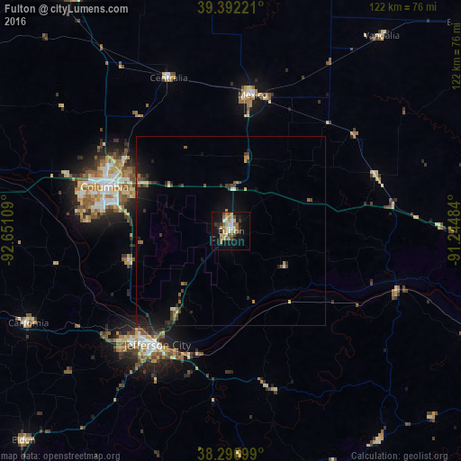
Analysis of Fulton night lights 2016
Square area 10x10 km:
 3.57%
3.57%90-99
3.57%80-89
5.1%70-79
4.08%60-69
6.63%50-59
3.57%40-49
3.91%30-39
2.55%20-29
2.89%10-19
28.57%0-9
35.54%Square area 50x50 km:
0.2%90-99
0.28%80-89
0.37%70-79
0.33%60-69
0.47%50-59
0.5%40-49
0.52%30-39
0.66%20-29
0.69%10-19
3.17%0-9
92.82%Clear (daylight) street map image can be seen on geolist.org.
Map coordinates:
39° 23' 32" North, 92° 39' 3.9" West
38° 50' 48.2" North, 91° 56' 52.7" West
38° 17' 49.2" North, 91° 14' 41.4" West
Some cities around Fulton sort by population:
• Columbia
35.4 km =22 mi,  289°
289°
• Jefferson City
35.8 km =22.2 mi,  213°
213°
• Moberly
76.3 km =47.4 mi,  326°
326°
• Mexico
36.4 km =22.6 mi,  8°
8°
• Troy
85 km =52.8 mi,  79°
79°
• Boonville
70.2 km =43.6 mi,  281°
281°
• Warrenton
70 km =43.5 mi,  93°
93°
• Bowling Green
85.2 km =52.9 mi,  49°
49°
4387496 (p: 12,939)
Sources (retrieved 2019-11-25):
» Earth at Night: Flat Maps 2012, 2016