Rolla night lights from space
Night Light of Rolla (Missouri) from space (United States) Src. Average luminocity for 10x10km area is 33.5244% and for 50x50km: 2.2765%.
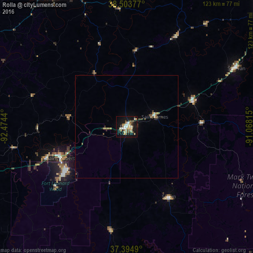
Analysis of Rolla night lights 2016
Square area 10x10 km:
 5.03%
5.03%90-99
6.01%80-89
6.01%70-79
3.41%60-69
3.41%50-59
4.22%40-49
4.71%30-39
2.92%20-29
3.9%10-19
39.61%0-9
20.78%Square area 50x50 km:
0.24%90-99
0.3%80-89
0.3%70-79
0.21%60-69
0.27%50-59
0.36%40-49
0.41%30-39
0.28%20-29
0.28%10-19
1.91%0-9
95.46%Clear (daylight) street map image can be seen on geolist.org.
Map coordinates:
38° 30' 13.6" North, 92° 28' 27.8" West
37° 57' 5.1" North, 91° 46' 16.6" West
37° 23' 41.6" North, 91° 4' 5.3" West
Some cities around Rolla sort by population:
• Jefferson City
77.9 km =48.4 mi,  333°
333°
• Fort Leonard Wood
43.5 km =27 mi,  231°
231°
• Lebanon
84 km =52.2 mi,  248°
248°
• Washington
94.6 km =58.8 mi,  44°
44°
• Fulton
100.7 km =62.6 mi,  351°
351°
• Union
86.7 km =53.9 mi,  50°
50°
• Sullivan
60.6 km =37.7 mi,  61°
61°
• Waynesville
40.1 km =24.9 mi, 250°
4406282 (p: 20,019)
Sources (retrieved 2019-11-25):
» Earth at Night: Flat Maps 2012, 2016