Fort Leonard Wood night lights from space
Night Light of Fort Leonard Wood (Missouri) from space (United States) Src. Average luminocity for 10x10km area is 20.1701% and for 50x50km: 4.2394%.
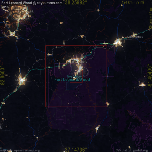
Analysis of Fort Leonard Wood night lights 2016
Square area 10x10 km:
 1.7%
1.7%90-99
3.06%80-89
3.91%70-79
1.53%60-69
1.87%50-59
3.91%40-49
1.53%30-39
2.72%20-29
5.1%10-19
21.43%0-9
53.23%Square area 50x50 km:
0.36%90-99
0.56%80-89
0.38%70-79
0.45%60-69
0.49%50-59
0.65%40-49
0.65%30-39
1.2%20-29
1.28%10-19
3.87%0-9
90.11%Clear (daylight) street map image can be seen on geolist.org.
Map coordinates:
38° 15' 35.7" North, 92° 51' 37.1" West
37° 42' 20.6" North, 92° 9' 25.8" West
37° 8' 50.5" North, 91° 27' 14.6" West
Some cities around Fort Leonard Wood sort by population:
• Jefferson City
96.9 km =60.2 mi,  359°
359°
• Rolla
43.5 km =27 mi,  51°
51°
• Lebanon
44.7 km =27.8 mi,  266°
266°
• West Plains
112 km =69.6 mi,  166°
166°
• Bolivar
110.8 km =68.8 mi,  264°
264°
• Marshfield
77.7 km =48.3 mi,  238°
238°
• Sullivan
103.7 km =64.4 mi,  57°
57°
• Waynesville
14.2 km =8.8 mi,  344°
344°
7259265 (p: 15,061)
Sources (retrieved 2019-11-25):
» Earth at Night: Flat Maps 2012, 2016