Watford City night lights from space
Night Light of Watford City (North Dakota) from space (United States) Src. Average luminocity for 10x10km area is 27.3824% and for 50x50km: 5.2561%.
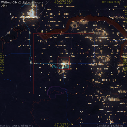
Analysis of Watford City night lights 2016
Square area 10x10 km:
 1.64%
1.64%90-99
3.42%80-89
2.53%70-79
3.13%60-69
6.1%50-59
4.91%40-49
6.4%30-39
2.23%20-29
3.27%10-19
39.43%0-9
26.93%Square area 50x50 km:
0.09%90-99
0.67%80-89
0.42%70-79
0.64%60-69
0.87%50-59
0.99%40-49
1.14%30-39
0.76%20-29
1.08%10-19
3.99%0-9
89.36%Clear (daylight) street map image can be seen on geolist.org.
Map coordinates:
48° 16' 20.6" North, 103° 59' 11" West
47° 48' 8.1" North, 103° 16' 59.7" West
47° 19' 40.1" North, 102° 34' 48.5" West
Some cities around Watford City sort by population:
• Minot
155.3 km =96.5 mi,  72°
72°
• Williston
45.7 km =28.4 mi,  326°
326°
• Dickinson
109.2 km =67.9 mi,  160°
160°
• Mandan
210.5 km =130.8 mi,  121°
121°
• Estevan, CA
149.6 km =93 mi,  8°
8°
• Sidney
65.9 km =40.9 mi,  261°
261°
• Minot Air Force Base
159.9 km =99.4 mi,  64°
64°
• Glendive
132.5 km =82.3 mi,  234°
234°
5692814 (p: 6,708)
Sources (retrieved 2019-11-25):
» Earth at Night: Flat Maps 2012, 2016