Minot Air Force Base night lights from space
Night Light of Minot Air Force Base (North Dakota) from space (United States) Src. Average luminocity for 10x10km area is 19.2827% and for 50x50km: 4.2926%.
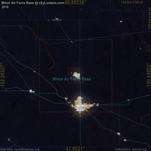
Analysis of Minot Air Force Base night lights 2016
Square area 10x10 km:
 4.83%
4.83%90-99
5.97%80-89
0%70-79
1.56%60-69
0.99%50-59
1.85%40-49
0.71%30-39
0.57%20-29
0%10-19
20.45%0-9
63.07%Square area 50x50 km:
0.94%90-99
0.99%80-89
0.41%70-79
0.41%60-69
0.49%50-59
0.46%40-49
0.28%30-39
0.29%20-29
0.89%10-19
2.91%0-9
91.95%Clear (daylight) street map image can be seen on geolist.org.
Map coordinates:
48° 53' 7.3" North, 102° 2' 32.2" West
48° 25' 15.1" North, 101° 20' 20.9" West
47° 57' 7.6" North, 100° 38' 9.7" West
Some cities around Minot Air Force Base sort by population:
• Bismarck
184.1 km =114.4 mi,  166°
166°
• Williston
171.3 km =106.4 mi,  259°
259°
• Brandon, CA
187.9 km =116.8 mi,  32°
32°
• Dickinson
202.9 km =126.1 mi,  212°
212°
• Mandan
180.4 km =112.1 mi, 169°
• Estevan, CA
144.2 km =89.6 mi,  303°
303°
• Devils Lake
186.3 km =115.8 mi,  100°
100°
• Watford City
159.9 km =99.4 mi,  244°
244°
7259396 (p: 5,521)
Sources (retrieved 2019-11-25):
» Earth at Night: Flat Maps 2012, 2016