Huntingburg night lights from space
Night Light of Huntingburg (Indiana) from space (United States) Src. Average luminocity for 10x10km area is 17.7143% and for 50x50km: 3.9547%.
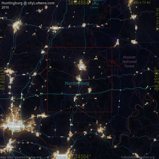
Analysis of Huntingburg night lights 2016
Square area 10x10 km:
 1.7%
1.7%90-99
1.36%80-89
1.87%70-79
0.68%60-69
2.89%50-59
3.74%40-49
4.08%30-39
2.72%20-29
1.87%10-19
18.37%0-9
60.71%Square area 50x50 km:
0.37%90-99
0.4%80-89
0.62%70-79
0.34%60-69
0.55%50-59
0.62%40-49
0.58%30-39
0.76%20-29
0.76%10-19
2.86%0-9
92.16%Clear (daylight) street map image can be seen on geolist.org.
Map coordinates:
38° 50' 55.1" North, 87° 39' 29.3" West
38° 17' 56.2" North, 86° 57' 18" West
37° 44' 42.1" North, 86° 15' 6.8" West
Some cities around Huntingburg sort by population:
• Evansville
63.7 km =39.6 mi,  235°
235°
• Owensboro
60 km =37.3 mi,  193°
193°
• Jasper
10.5 km =6.5 mi,  11°
11°
• Washington
44.3 km =27.5 mi,  334°
334°
• Princeton
53.8 km =33.4 mi,  276°
276°
• Tell City
42 km =26.1 mi,  157°
157°
• Knottsville
58.8 km =36.5 mi,  175°
175°
• Boonville
39.4 km =24.5 mi,  225°
225°
4259271 (p: 6,035)
Sources (retrieved 2019-11-25):
» Earth at Night: Flat Maps 2012, 2016