Warrenville night lights from space
Night Light of Warrenville (Illinois) from space (United States) Src. Average luminocity for 10x10km area is 82.1288% and for 50x50km: 75.7768%.
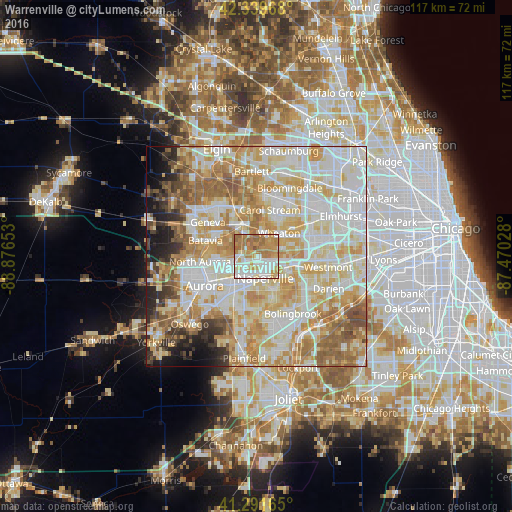
Analysis of Warrenville night lights 2016
Square area 10x10 km:
 20.3%
20.3%90-99
22.12%80-89
8.64%70-79
21.97%60-69
20.91%50-59
5.91%40-49
0.15%30-39
0%20-29
0%10-19
0%0-9
0%Square area 50x50 km:
20.14%90-99
20.23%80-89
14.21%70-79
12.8%60-69
10.64%50-59
6.8%40-49
3.2%30-39
2.75%20-29
3.56%10-19
3.95%0-9
1.71%Clear (daylight) street map image can be seen on geolist.org.
Map coordinates:
42° 20' 22.8" North, 88° 52' 35.5" West
41° 49' 4.1" North, 88° 10' 24.2" West
41° 17' 29.9" North, 87° 28' 13" West
Some cities around Warrenville sort by population:
• Naperville
4.2 km =2.6 mi,  148°
148°
• Wheaton
7.7 km =4.8 mi,  45°
45°
• Carol Stream
11 km =6.8 mi,  16°
16°
• Glen Ellyn
11 km =6.8 mi, 53°
• West Chicago
7.9 km =4.9 mi,  341°
341°
• Batavia
12.1 km =7.5 mi,  287°
287°
• Lisle
8.4 km =5.2 mi,  102°
102°
• Winfield
5 km =3.1 mi,  11°
11°
4915525 (p: 13,317)
Sources (retrieved 2019-11-25):
» Earth at Night: Flat Maps 2012, 2016