Wallingford Center night lights from space
Night Light of Wallingford Center (Connecticut) from space (United States) Src. Average luminocity for 10x10km area is 57.3027% and for 50x50km: 39.4958%.
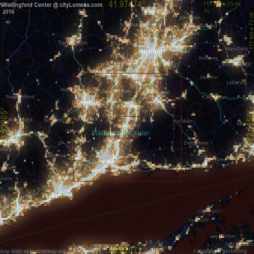
Analysis of Wallingford Center night lights 2016
Square area 10x10 km:
 7.48%
7.48%90-99
7.31%80-89
8.67%70-79
8.16%60-69
10.71%50-59
18.03%40-49
13.61%30-39
9.69%20-29
10.71%10-19
5.44%0-9
0.17%Square area 50x50 km:
4.93%90-99
5.8%80-89
4.71%70-79
5.68%60-69
7.09%50-59
9.24%40-49
8.32%30-39
7.83%20-29
9.77%10-19
11.86%0-9
24.78%Clear (daylight) street map image can be seen on geolist.org.
Map coordinates:
41° 58' 29.1" North, 73° 31' 19.4" West
41° 26' 59.5" North, 72° 49' 8.1" West
40° 55' 14.6" North, 72° 6' 56.9" West
Some cities around Wallingford Center sort by population:
• New Haven
18.2 km =11.3 mi,  210°
210°
• Meriden
9.9 km =6.2 mi,  5°
5°
• Hamden
8.8 km =5.5 mi,  227°
227°
• Cheshire
8.7 km =5.4 mi,  308°
308°
• North Haven
7.4 km =4.6 mi, 207°
• North Branford
14.3 km =8.9 mi,  162°
162°
• Prospect
14.5 km =9 mi,  293°
293°
• Cheshire Village
8.9 km =5.5 mi, 311°
7257422 (p: 18,209)
Sources (retrieved 2019-11-25):
» Earth at Night: Flat Maps 2012, 2016