Woodlyn night lights from space
Night Light of Woodlyn (Pennsylvania) from space (United States) Src. Average luminocity for 10x10km area is 84.4269% and for 50x50km: 70.8232%.
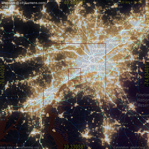
Analysis of Woodlyn night lights 2016
Square area 10x10 km:
 27.89%
90-99
26.7%80-89
8.67%70-79
13.44%60-69
7.82%50-59
11.9%40-49
3.57%30-39
0%20-29
0%10-19
0%0-9
0%Square area 50x50 km:
22.1%90-99
15.05%80-89
8.24%70-79
10.45%60-69
12.01%50-59
9.25%40-49
6.8%30-39
5.63%20-29
3.91%10-19
3.47%0-9
3.1%Clear (daylight) street map image can be seen on geolist.org.
Map coordinates:
40° 24' 35.4" North, 76° 2' 24.9" West
39° 52' 20.4" North, 75° 20' 13.7" West
39° 19' 50.1" North, 74° 38' 2.4" West
Some cities around Woodlyn sort by population:
• Chester
3 km =1.9 mi,  214°
214°
• Folsom
2.2 km =1.4 mi,  27°
27°
• Brookhaven
3.9 km =2.4 mi,  264°
264°
• Ridley Park
1.5 km =0.9 mi,  49°
49°
• Folcroft
5 km =3.1 mi,  65°
65°
• Prospect Park
3 km =1.9 mi, 54°
• Swarthmore
3.5 km =2.2 mi,  341°
341°
• Norwood
3.9 km =2.4 mi,  55°
55°
4562366 (p: 9,485)
Sources (retrieved 2019-11-25):
» Earth at Night: Flat Maps 2012, 2016