Claymont night lights from space
Night Light of Claymont (Delaware) from space (United States) Src. Average luminocity for 10x10km area is 71.9728% and for 50x50km: 57.5825%.
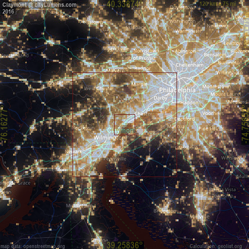
Analysis of Claymont night lights 2016
Square area 10x10 km:
 13.78%
90-99
15.65%80-89
7.31%70-79
16.33%60-69
19.05%50-59
5.61%40-49
15.31%30-39
6.97%20-29
0%10-19
0%0-9
0%Square area 50x50 km:
13.59%90-99
10.94%80-89
7.25%70-79
9%60-69
10.14%50-59
9.34%40-49
7.96%30-39
7.53%20-29
6.08%10-19
6.85%0-9
11.32%Clear (daylight) street map image can be seen on geolist.org.
Map coordinates:
40° 20' 19.5" North, 76° 9' 46" West
39° 48' 2.4" North, 75° 27' 34.7" West
39° 15' 30.1" North, 74° 45' 23.5" West
Some cities around Claymont sort by population:
• Wilmington
9.6 km =6 mi,  230°
230°
• Chester
10.3 km =6.4 mi,  58°
58°
• Woodlyn
13.1 km =8.1 mi,  52°
52°
• Brookhaven
10.1 km =6.3 mi,  40°
40°
• Village Green-Green Ridge
7.6 km =4.7 mi,  22°
22°
• Carneys Point
10 km =6.2 mi,  185°
185°
• Elsmere
13.7 km =8.5 mi,  240°
240°
• Edgemoor
6.6 km =4.1 mi,  211°
211°
4141974 (p: 8,253)
Sources (retrieved 2019-11-25):
» Earth at Night: Flat Maps 2012, 2016