Swarthmore night lights from space
Night Light of Swarthmore (Pennsylvania) from space (United States) Src. Average luminocity for 10x10km area is 87.881% and for 50x50km: 72.5258%.
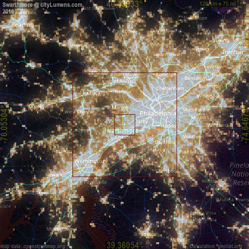
Analysis of Swarthmore night lights 2016
Square area 10x10 km:
 30.44%
90-99
25.34%80-89
13.95%70-79
16.33%60-69
12.41%50-59
1.53%40-49
0%30-39
0%20-29
0%10-19
0%0-9
0%Square area 50x50 km:
22.14%90-99
14.91%80-89
9.04%70-79
11.39%60-69
12.54%50-59
9.53%40-49
7.01%30-39
5.68%20-29
3.86%10-19
3.14%0-9
0.77%Clear (daylight) street map image can be seen on geolist.org.
Map coordinates:
40° 26' 21.6" North, 76° 3' 10.9" West
39° 54' 7.4" North, 75° 20' 59.7" West
39° 21' 37.9" North, 74° 38' 48.4" West
Some cities around Swarthmore sort by population:
• Springfield
4.1 km =2.5 mi,  38°
38°
• Woodlyn
3.5 km =2.2 mi,  161°
161°
• Folsom
2.5 km =1.6 mi,  122°
122°
• Brookhaven
4.6 km =2.9 mi,  217°
217°
• Ridley Park
3.2 km =2 mi,  136°
136°
• Prospect Park
3.9 km =2.4 mi,  113°
113°
• Norwood
4.4 km =2.7 mi,  104°
104°
• Media
3.6 km =2.2 mi,  296°
296°
4561628 (p: 6,211)
Sources (retrieved 2019-11-25):
» Earth at Night: Flat Maps 2012, 2016