Brookhaven night lights from space
Night Light of Brookhaven (Pennsylvania) from space (United States) Src. Average luminocity for 10x10km area is 84.0442% and for 50x50km: 68.5383%.
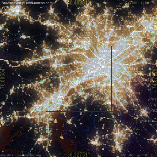
Analysis of Brookhaven night lights 2016
Square area 10x10 km:
 23.13%
90-99
26.87%80-89
8.33%70-79
18.88%60-69
15.48%50-59
4.42%40-49
2.89%30-39
0%20-29
0%10-19
0%0-9
0%Square area 50x50 km:
20.15%90-99
13.62%80-89
7.99%70-79
10.3%60-69
12.32%50-59
9.78%40-49
7.41%30-39
6.51%20-29
4.94%10-19
3.88%0-9
3.1%Clear (daylight) street map image can be seen on geolist.org.
Map coordinates:
40° 24' 24.5" North, 76° 5' 7.9" West
39° 52' 9.4" North, 75° 22' 56.7" West
39° 19' 39" North, 74° 40' 45.4" West
Some cities around Brookhaven sort by population:
• Chester
3.1 km =1.9 mi,  135°
135°
• Woodlyn
3.9 km =2.4 mi,  84°
84°
• Folsom
5.4 km =3.4 mi,  64°
64°
• Village Green-Green Ridge
3.7 km =2.3 mi,  260°
260°
• Ridley Park
5.2 km =3.2 mi, 75°
• Prospect Park
6.7 km =4.2 mi,  71°
71°
• Swarthmore
4.6 km =2.9 mi,  37°
37°
• Media
5.3 km =3.3 mi,  355°
355°
4556793 (p: 8,078)
Sources (retrieved 2019-11-25):
» Earth at Night: Flat Maps 2012, 2016