Folsom night lights from space
Night Light of Folsom (Pennsylvania) from space (United States) Src. Average luminocity for 10x10km area is 90.2942% and for 50x50km: 73.315%.
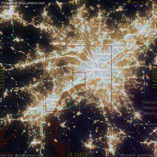
Analysis of Folsom night lights 2016
Square area 10x10 km:
 36.39%
90-99
29.08%80-89
9.86%70-79
15.31%60-69
5.78%50-59
3.57%40-49
0%30-39
0%20-29
0%10-19
0%0-9
0%Square area 50x50 km:
23.1%90-99
16.09%80-89
8.78%70-79
11.11%60-69
12.05%50-59
9.11%40-49
6.66%30-39
5.23%20-29
3.49%10-19
3%0-9
1.38%Clear (daylight) street map image can be seen on geolist.org.
Map coordinates:
40° 25' 37.9" North, 76° 1' 42" West
39° 53' 23.4" North, 75° 19' 30.7" West
39° 20' 53.6" North, 74° 37' 19.5" West
Some cities around Folsom sort by population:
• Springfield
4.6 km =2.9 mi,  5°
5°
• Woodlyn
2.2 km =1.4 mi,  207°
207°
• Glenolden
3.3 km =2.1 mi,  69°
69°
• Ridley Park
1 km =0.6 mi,  172°
172°
• Folcroft
3.5 km =2.2 mi,  87°
87°
• Prospect Park
1.5 km =0.9 mi,  98°
98°
• Swarthmore
2.5 km =1.6 mi,  302°
302°
• Norwood
2.2 km =1.4 mi,  84°
84°
4558002 (p: 8,323)
Sources (retrieved 2019-11-25):
» Earth at Night: Flat Maps 2012, 2016