Vermilion night lights from space
Night Light of Vermilion (Ohio) from space (United States) Src. Average luminocity for 10x10km area is 19.6395% and for 50x50km: 15.6104%.
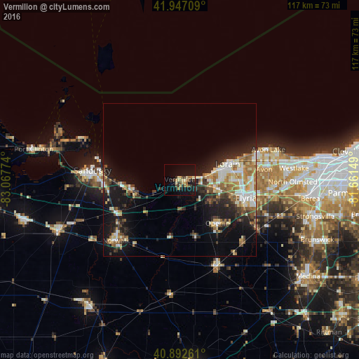
Analysis of Vermilion night lights 2016
Square area 10x10 km:
 0%
0%90-99
1.36%80-89
5.78%70-79
2.38%60-69
3.57%50-59
1.7%40-49
2.89%30-39
4.08%20-29
1.7%10-19
24.15%0-9
52.38%Square area 50x50 km:
1.78%90-99
3.14%80-89
2.24%70-79
1.5%60-69
2.56%50-59
2.01%40-49
1.84%30-39
2.27%20-29
4.02%10-19
11.25%0-9
67.39%Clear (daylight) street map image can be seen on geolist.org.
Map coordinates:
41° 56' 49.5" North, 83° 4' 3.9" West
41° 25' 19.2" North, 82° 21' 52.6" West
40° 53' 33.4" North, 81° 39' 41.4" West
Some cities around Vermilion sort by population:
• Lorain
15.6 km =9.7 mi,  77°
77°
• Elyria
22.2 km =13.8 mi,  105°
105°
• Sandusky
28.8 km =17.9 mi,  275°
275°
• Avon
27.6 km =17.1 mi, 83°
• Amherst
12.2 km =7.6 mi,  102°
102°
• Sheffield Lake
23.1 km =14.4 mi,  71°
71°
• Oberlin
18.8 km =11.7 mi,  139°
139°
• Huron
16.2 km =10.1 mi,  259°
259°
5175072 (p: 10,434)
Sources (retrieved 2019-11-25):
» Earth at Night: Flat Maps 2012, 2016