Amherst night lights from space
Night Light of Amherst (Ohio) from space (United States) Src. Average luminocity for 10x10km area is 59.5119% and for 50x50km: 21.1101%.
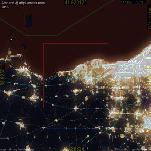
Analysis of Amherst night lights 2016
Square area 10x10 km:
 6.97%
6.97%90-99
12.76%80-89
9.01%70-79
8.33%60-69
11.73%50-59
12.93%40-49
7.99%30-39
14.12%20-29
11.56%10-19
4.59%0-9
0%Square area 50x50 km:
2.52%90-99
4.28%80-89
3.16%70-79
2.73%60-69
5.06%50-59
2.39%40-49
2.05%30-39
2.73%20-29
5.19%10-19
8.42%0-9
61.47%Clear (daylight) street map image can be seen on geolist.org.
Map coordinates:
41° 55' 23.2" North, 82° 55' 31.8" West
41° 23' 52.2" North, 82° 13' 20.6" West
40° 52' 5.7" North, 81° 31' 9.3" West
Some cities around Amherst sort by population:
• Lorain
7 km =4.3 mi,  28°
28°
• Elyria
10.1 km =6.3 mi,  108°
108°
• North Ridgeville
17 km =10.6 mi,  93°
93°
• Avon
16.7 km =10.4 mi,  68°
68°
• Vermilion-on-the-Lake
9.1 km =5.7 mi,  291°
291°
• Vermilion
12.2 km =7.6 mi,  282°
282°
• Sheffield Lake
14.2 km =8.8 mi,  45°
45°
• Oberlin
11.6 km =7.2 mi,  177°
177°
5145695 (p: 12,135)
Sources (retrieved 2019-11-25):
» Earth at Night: Flat Maps 2012, 2016