Huron night lights from space
Night Light of Huron (Ohio) from space (United States) Src. Average luminocity for 10x10km area is 20.9184% and for 50x50km: 10.2175%.
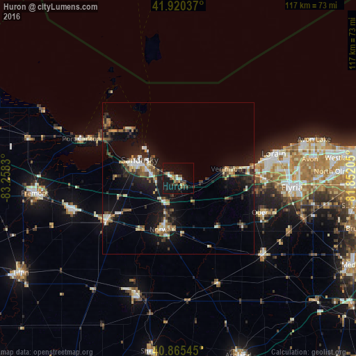
Analysis of Huron night lights 2016
Square area 10x10 km:
 1.7%
1.7%90-99
2.89%80-89
0.85%70-79
2.55%60-69
2.89%50-59
2.04%40-49
5.61%30-39
5.27%20-29
2.72%10-19
29.93%0-9
43.54%Square area 50x50 km:
0.84%90-99
1.36%80-89
1.06%70-79
0.94%60-69
1.21%50-59
1.47%40-49
1.52%30-39
2.1%20-29
3.08%10-19
10.68%0-9
75.75%Clear (daylight) street map image can be seen on geolist.org.
Map coordinates:
41° 55' 13.3" North, 83° 15' 29.9" West
41° 23' 42.2" North, 82° 33' 18.6" West
40° 51' 55.6" North, 81° 51' 7.4" West
Some cities around Huron sort by population:
• Lorain
31.7 km =19.7 mi,  78°
78°
• Sandusky
14.1 km =8.8 mi,  295°
295°
• Norwalk
17.7 km =11 mi,  196°
196°
• Amherst
27.8 km =17.3 mi,  89°
89°
• Vermilion-on-the-Lake
19.6 km =12.2 mi, 79°
• Vermilion
16.2 km =10.1 mi, 79°
• Oberlin
30.4 km =18.9 mi,  111°
111°
• Bellevue
27.5 km =17.1 mi,  240°
240°
5158298 (p: 7,022)
Sources (retrieved 2019-11-25):
» Earth at Night: Flat Maps 2012, 2016