Uxbridge night lights from space
Night Light of Uxbridge (Massachusetts) from space (United States) Src. Average luminocity for 10x10km area is 18.827% and for 50x50km: 33.6306%.
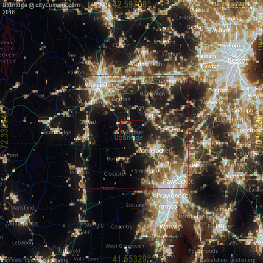
Analysis of Uxbridge night lights 2016
Square area 10x10 km:
 0%
0%90-99
1.11%80-89
3.02%70-79
1.9%60-69
3.49%50-59
1.27%40-49
3.97%30-39
2.54%20-29
4.92%10-19
31.43%0-9
46.35%Square area 50x50 km:
4.53%90-99
5.24%80-89
4.03%70-79
4.17%60-69
5.17%50-59
6.08%40-49
5.34%30-39
6.37%20-29
11.29%10-19
18.83%0-9
28.96%Clear (daylight) street map image can be seen on geolist.org.
Map coordinates:
42° 35' 49.4" North, 72° 19' 57.5" West
42° 4' 38.4" North, 71° 37' 46.2" West
41° 33' 11.8" North, 70° 55' 35" West
Some cities around Uxbridge sort by population:
• Woonsocket
12.6 km =7.8 mi,  131°
131°
• Milford
11.6 km =7.2 mi,  53°
53°
• Northbridge
8.4 km =5.2 mi,  348°
348°
• Sutton
13.7 km =8.5 mi,  306°
306°
• Blackstone
9.8 km =6.1 mi, 132°
• Douglas
9.4 km =5.8 mi,  254°
254°
• Whitinsville
4.8 km =3 mi,  321°
321°
• Mendon
7.1 km =4.4 mi,  63°
63°
4953804 (p: 12,614)
Sources (retrieved 2019-11-25):
» Earth at Night: Flat Maps 2012, 2016