Whitinsville night lights from space
Night Light of Whitinsville (Massachusetts) from space (United States) Src. Average luminocity for 10x10km area is 24.0288% and for 50x50km: 32.8431%.
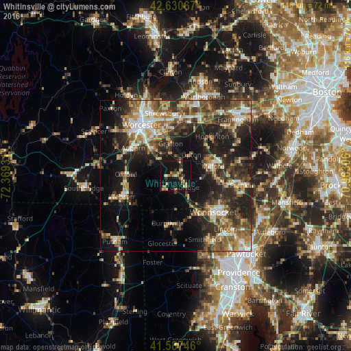
Analysis of Whitinsville night lights 2016
Square area 10x10 km:
 0.45%
0.45%90-99
2.12%80-89
5%70-79
2.73%60-69
4.55%50-59
1.21%40-49
3.18%30-39
3.79%20-29
8.94%10-19
41.21%0-9
26.82%Square area 50x50 km:
3.74%90-99
4.88%80-89
4.17%70-79
4.02%60-69
5.24%50-59
6.04%40-49
5.9%30-39
6.6%20-29
11.26%10-19
17.54%0-9
30.63%Clear (daylight) street map image can be seen on geolist.org.
Map coordinates:
42° 37' 50.4" North, 72° 22' 9.5" West
42° 6' 40.4" North, 71° 39' 58.2" West
41° 35' 14.9" North, 70° 57' 47" West
Some cities around Whitinsville sort by population:
• Milford
12.8 km =8 mi,  75°
75°
• Grafton
10.8 km =6.7 mi,  351°
351°
• Northbridge
4.7 km =2.9 mi,  17°
17°
• Millbury
12 km =7.5 mi,  319°
319°
• Uxbridge
4.8 km =3 mi,  141°
141°
• Sutton
9.1 km =5.7 mi,  298°
298°
• Douglas
8.8 km =5.5 mi,  223°
223°
• Mendon
9.4 km =5.8 mi,  93°
93°
4955539 (p: 6,704)
Sources (retrieved 2019-11-25):
» Earth at Night: Flat Maps 2012, 2016