Sutton night lights from space
Night Light of Sutton (Massachusetts) from space (United States) Src. Average luminocity for 10x10km area is 21.0803% and for 50x50km: 28.1589%.
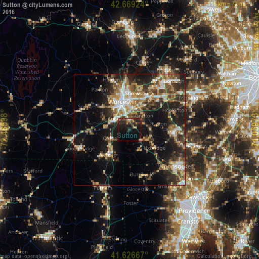
Analysis of Sutton night lights 2016
Square area 10x10 km:
 0.91%
0.91%90-99
1.97%80-89
1.82%70-79
1.67%60-69
2.42%50-59
1.82%40-49
3.18%30-39
7.58%20-29
15.15%10-19
25.45%0-9
38.03%Square area 50x50 km:
3.2%90-99
4.2%80-89
3.67%70-79
3.39%60-69
4.22%50-59
4.59%40-49
4.73%30-39
5.42%20-29
9.73%10-19
16.68%0-9
40.16%Clear (daylight) street map image can be seen on geolist.org.
Map coordinates:
42° 40' 9.3" North, 72° 27' 57.5" West
42° 9' 0.4" North, 71° 45' 46.3" West
41° 37' 36" North, 71° 3' 35" West
Some cities around Sutton sort by population:
• Auburn
7.8 km =4.8 mi,  309°
309°
• Grafton
9 km =5.6 mi,  45°
45°
• Northbridge
9.3 km =5.8 mi,  89°
89°
• Millbury
4.9 km =3 mi,  2°
2°
• Hamilton Worcester
11.8 km =7.3 mi,  358°
358°
• Douglas
10.8 km =6.7 mi,  169°
169°
• Whitinsville
9.1 km =5.7 mi,  118°
118°
• Oxford
9.2 km =5.7 mi,  246°
246°
4952444 (p: 9,215)
Sources (retrieved 2019-11-25):
» Earth at Night: Flat Maps 2012, 2016