University Park night lights from space
Night Light of University Park (Illinois) from space (United States) Src. Average luminocity for 10x10km area is 55.835% and for 50x50km: 47.1756%.
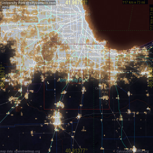
Analysis of University Park night lights 2016
Square area 10x10 km:
 6.46%
6.46%90-99
8.33%80-89
10.03%70-79
8.67%60-69
14.12%50-59
12.76%40-49
4.59%30-39
8.5%20-29
15.48%10-19
11.05%0-9
0%Square area 50x50 km:
12.3%90-99
10.64%80-89
7.15%70-79
7.39%60-69
7.5%50-59
5.81%40-49
2.63%30-39
3.15%20-29
4.19%10-19
7.17%0-9
32.08%Clear (daylight) street map image can be seen on geolist.org.
Map coordinates:
41° 58' 4.5" North, 88° 23' 12.2" West
41° 26' 34.7" North, 87° 41' 1" West
40° 54' 49.6" North, 86° 58' 49.7" West
Some cities around University Park sort by population:
• Chicago Heights
8.1 km =5 mi,  29°
29°
• Park Forest
5.4 km =3.4 mi,  8°
8°
• Matteson
7.2 km =4.5 mi,  340°
340°
• Richton Park
4.9 km =3 mi, 340°
• Sauk Village
10.9 km =6.8 mi,  62°
62°
• Steger
4.9 km =3 mi,  52°
52°
• Crete
4.4 km =2.7 mi,  87°
87°
• Monee
5.5 km =3.4 mi,  242°
242°
7535510 (p: 7,070)
Sources (retrieved 2019-11-25):
» Earth at Night: Flat Maps 2012, 2016