Sauk Village night lights from space
Night Light of Sauk Village (Illinois) from space (United States) Src. Average luminocity for 10x10km area is 72.1514% and for 50x50km: 55.023%.
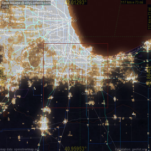
Analysis of Sauk Village night lights 2016
Square area 10x10 km:
 9.69%
9.69%90-99
12.93%80-89
11.56%70-79
18.2%60-69
24.15%50-59
9.69%40-49
9.52%30-39
4.08%20-29
0.17%10-19
0%0-9
0%Square area 50x50 km:
16.89%90-99
13.62%80-89
7.24%70-79
7.6%60-69
7.76%50-59
4.81%40-49
3.04%30-39
3.58%20-29
4.66%10-19
7.61%0-9
23.2%Clear (daylight) street map image can be seen on geolist.org.
Map coordinates:
42° 0' 46.5" North, 88° 16' 14.4" West
41° 29' 18.1" North, 87° 34' 3.1" West
40° 57' 34.3" North, 86° 51' 51.9" West
Some cities around Sauk Village sort by population:
• Chicago Heights
6 km =3.7 mi,  289°
289°
• Lansing
8.8 km =5.5 mi,  15°
15°
• Park Forest
8.9 km =5.5 mi,  272°
272°
• Dyer
3.9 km =2.4 mi,  80°
80°
• Steger
6.1 km =3.8 mi,  250°
250°
• Lynwood
4.9 km =3 mi,  29°
29°
• Glenwood
6.7 km =4.2 mi,  334°
334°
• Crete
7.2 km =4.5 mi,  227°
227°
4910634 (p: 10,493)
Sources (retrieved 2019-11-25):
» Earth at Night: Flat Maps 2012, 2016