Monee night lights from space
Night Light of Monee (Illinois) from space (United States) Src. Average luminocity for 10x10km area is 43.2636% and for 50x50km: 42.1525%.
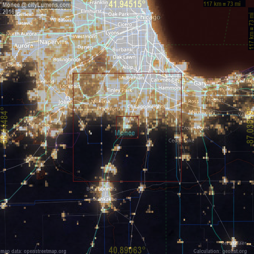
Analysis of Monee night lights 2016
Square area 10x10 km:
 4.59%
4.59%90-99
7.65%80-89
4.76%70-79
4.42%60-69
5.61%50-59
8.67%40-49
9.86%30-39
14.97%20-29
11.56%10-19
21.77%0-9
6.12%Square area 50x50 km:
10.49%90-99
9.22%80-89
6.35%70-79
6.85%60-69
7.15%50-59
5.39%40-49
2.35%30-39
2.63%20-29
4.19%10-19
7.01%0-9
38.37%Clear (daylight) street map image can be seen on geolist.org.
Map coordinates:
41° 56' 42.5" North, 88° 26' 41.4" West
41° 25' 12.1" North, 87° 44' 30.2" West
40° 53' 26.3" North, 87° 2' 18.9" West
Some cities around Monee sort by population:
• Park Forest
9.7 km =6 mi,  35°
35°
• Matteson
9.6 km =6 mi,  14°
14°
• Frankfort
12.3 km =7.6 mi,  313°
313°
• Richton Park
7.8 km =4.8 mi,  24°
24°
• Steger
10.4 km =6.5 mi,  57°
57°
• Frankfort Square
12.1 km =7.5 mi,  335°
335°
• Crete
9.6 km =6 mi,  73°
73°
• University Park
5.5 km =3.4 mi, 62°
4902498 (p: 5,082)
Sources (retrieved 2019-11-25):
» Earth at Night: Flat Maps 2012, 2016