Union night lights from space
Night Light of Union (Missouri) from space (United States) Src. Average luminocity for 10x10km area is 27.9886% and for 50x50km: 6.3848%.
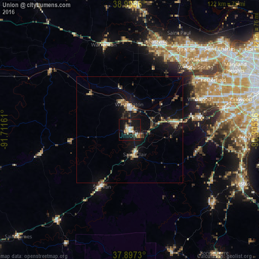
Analysis of Union night lights 2016
Square area 10x10 km:
 2.92%
2.92%90-99
4.22%80-89
4.38%70-79
4.22%60-69
2.92%50-59
2.11%40-49
1.95%30-39
6.98%20-29
1.95%10-19
43.99%0-9
24.35%Square area 50x50 km:
0.5%90-99
0.58%80-89
0.89%70-79
0.7%60-69
0.68%50-59
0.83%40-49
0.93%30-39
1.74%20-29
0.77%10-19
7.41%0-9
84.96%Clear (daylight) street map image can be seen on geolist.org.
Map coordinates:
38° 59' 55" North, 91° 42' 41.8" West
38° 27' 0.2" North, 91° 0' 30.5" West
37° 53' 50.3" North, 90° 18' 19.3" West
Some cities around Union sort by population:
• Wildwood
33.5 km =20.8 mi,  63°
63°
• Washington
12 km =7.5 mi,  358°
358°
• Eureka
33.6 km =20.9 mi,  80°
80°
• Ellisville
39.9 km =24.8 mi,  66°
66°
• Warrenton
41.8 km =26 mi,  343°
343°
• Pacific
23.5 km =14.6 mi, 81°
• Sullivan
30 km =18.6 mi,  206°
206°
• Weldon Spring
40.3 km =25 mi,  43°
43°
4412454 (p: 10,957)
Sources (retrieved 2019-11-25):
» Earth at Night: Flat Maps 2012, 2016