Pacific night lights from space
Night Light of Pacific (Missouri) from space (United States) Src. Average luminocity for 10x10km area is 26.1607% and for 50x50km: 21.3661%.
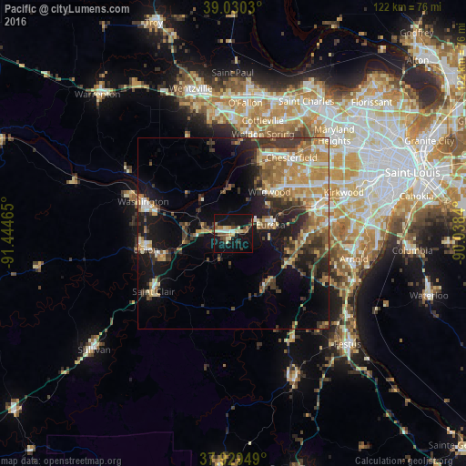
Analysis of Pacific night lights 2016
Square area 10x10 km:
 2.11%
2.11%90-99
3.08%80-89
5.19%70-79
2.92%60-69
2.92%50-59
2.27%40-49
4.06%30-39
4.38%20-29
2.44%10-19
47.4%0-9
23.21%Square area 50x50 km:
2.25%90-99
2.5%80-89
2.79%70-79
4.46%60-69
3.74%50-59
3.09%40-49
2.78%30-39
4.78%20-29
4.6%10-19
12.51%0-9
56.51%Clear (daylight) street map image can be seen on geolist.org.
Map coordinates:
39° 1' 49.1" North, 91° 26' 40.7" West
38° 28' 55.2" North, 90° 44' 29.5" West
37° 55' 46.2" North, 90° 2' 18.2" West
Some cities around Pacific sort by population:
• Wildwood
13.1 km =8.1 mi,  31°
31°
• Ballwin
21.1 km =13.1 mi,  53°
53°
• Manchester
23.9 km =14.9 mi,  57°
57°
• Union
23.5 km =14.6 mi,  261°
261°
• Eureka
10.1 km =6.3 mi,  76°
76°
• Ellisville
18.2 km =11.3 mi, 47°
• Murphy
22.2 km =13.8 mi,  87°
87°
• Valley Park
22.9 km =14.2 mi,  70°
70°
4402300 (p: 7,161)
Sources (retrieved 2019-11-25):
» Earth at Night: Flat Maps 2012, 2016