Warrenton night lights from space
Night Light of Warrenton (Missouri) from space (United States) Src. Average luminocity for 10x10km area is 22.8588% and for 50x50km: 6.5307%.
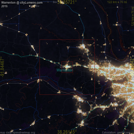
Analysis of Warrenton night lights 2016
Square area 10x10 km:
 1.53%
1.53%90-99
4.25%80-89
3.57%70-79
2.89%60-69
2.72%50-59
2.21%40-49
3.91%30-39
3.4%20-29
1.7%10-19
23.13%0-9
50.68%Square area 50x50 km:
0.37%90-99
0.62%80-89
0.98%70-79
0.78%60-69
0.83%50-59
1.02%40-49
1.14%30-39
1.75%20-29
1.2%10-19
5.54%0-9
85.77%Clear (daylight) street map image can be seen on geolist.org.
Map coordinates:
39° 21' 26" North, 91° 50' 40.8" West
38° 48' 41.2" North, 91° 8' 29.5" West
38° 15' 41.2" North, 90° 26' 18.3" West
Some cities around Warrenton sort by population:
• O'Fallon
38.3 km =23.8 mi,  90°
90°
• Wentzville
25 km =15.5 mi, 90°
• Lake Saint Louis
30.9 km =19.2 mi, 92°
• Washington
30.3 km =18.8 mi,  158°
158°
• Dardenne Prairie
36.1 km =22.4 mi,  97°
97°
• Troy
23.3 km =14.5 mi,  36°
36°
• Union
41.8 km =26 mi, 163°
• Weldon Spring
40.7 km =25.3 mi,  105°
105°
4413598 (p: 8,106)
Sources (retrieved 2019-11-25):
» Earth at Night: Flat Maps 2012, 2016