Eureka night lights from space
Night Light of Eureka (Missouri) from space (United States) Src. Average luminocity for 10x10km area is 30.5942% and for 50x50km: 34.1691%.
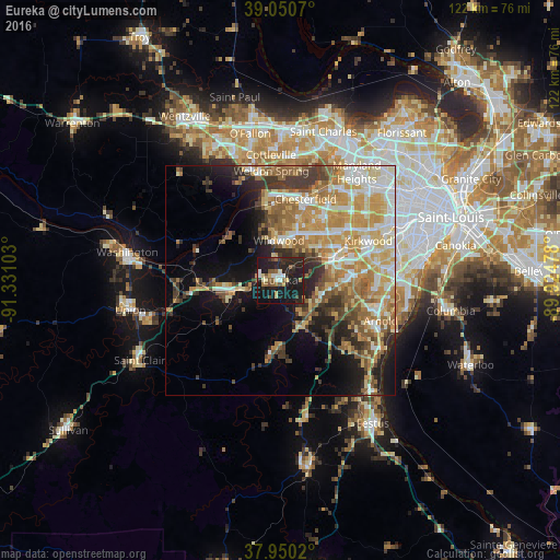
Analysis of Eureka night lights 2016
Square area 10x10 km:
 2.6%
2.6%90-99
4.22%80-89
2.27%70-79
3.25%60-69
2.11%50-59
6.66%40-49
3.57%30-39
2.6%20-29
22.08%10-19
45.45%0-9
5.19%Square area 50x50 km:
4.9%90-99
6.03%80-89
5.17%70-79
7.86%60-69
5.57%50-59
5.01%40-49
3.41%30-39
4.71%20-29
5.71%10-19
10.57%0-9
41.06%Clear (daylight) street map image can be seen on geolist.org.
Map coordinates:
39° 3' 2.5" North, 91° 19' 51.7" West
38° 30' 9.2" North, 90° 37' 40.4" West
37° 57' 0.7" North, 89° 55' 29.2" West
Some cities around Eureka sort by population:
• Chesterfield
18.4 km =11.4 mi,  13°
13°
• Wildwood
9.4 km =5.8 mi,  341°
341°
• Ballwin
12.5 km =7.8 mi,  34°
34°
• Manchester
14.7 km =9.1 mi,  44°
44°
• Ellisville
10.6 km =6.6 mi,  19°
19°
• Murphy
12.3 km =7.6 mi,  96°
96°
• Pacific
10.1 km =6.3 mi,  256°
256°
• Valley Park
12.9 km =8 mi,  66°
66°
4385835 (p: 10,602)
Sources (retrieved 2019-11-25):
» Earth at Night: Flat Maps 2012, 2016