Ellisville night lights from space
Night Light of Ellisville (Missouri) from space (United States) Src. Average luminocity for 10x10km area is 68.7045% and for 50x50km: 52.0395%.
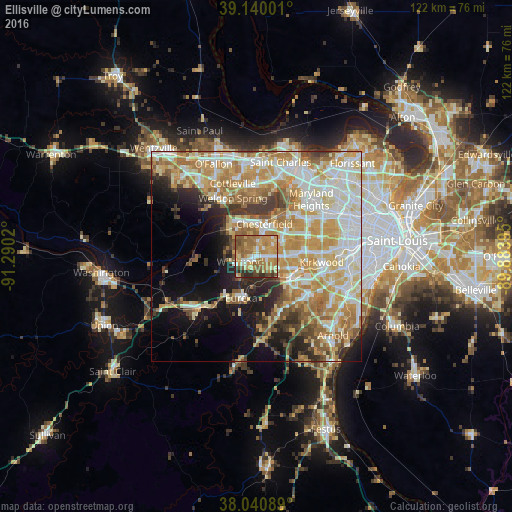
Analysis of Ellisville night lights 2016
Square area 10x10 km:
 7.14%
7.14%90-99
8.77%80-89
12.99%70-79
22.89%60-69
19.81%50-59
11.85%40-49
7.14%30-39
4.22%20-29
5.19%10-19
0%0-9
0%Square area 50x50 km:
10.9%90-99
11.41%80-89
8.23%70-79
10.9%60-69
8.56%50-59
5.72%40-49
3.52%30-39
4.44%20-29
5.57%10-19
9.02%0-9
21.73%Clear (daylight) street map image can be seen on geolist.org.
Map coordinates:
39° 8' 24" North, 91° 17' 24.7" West
38° 35' 33.2" North, 90° 35' 13.5" West
38° 2' 27.2" North, 89° 53' 2.2" West
Some cities around Ellisville sort by population:
• Chesterfield
7.9 km =4.9 mi,  6°
6°
• Wildwood
6.7 km =4.2 mi,  260°
260°
• Ballwin
3.6 km =2.2 mi,  85°
85°
• Manchester
6.8 km =4.2 mi, 85°
• Town and Country
11 km =6.8 mi,  78°
78°
• Eureka
10.6 km =6.6 mi,  199°
199°
• Des Peres
13.4 km =8.3 mi, 86°
• Valley Park
9.5 km =5.9 mi,  120°
120°
4385494 (p: 9,284)
Sources (retrieved 2019-11-25):
» Earth at Night: Flat Maps 2012, 2016