Weldon Spring night lights from space
Night Light of Weldon Spring (Missouri) from space (United States) Src. Average luminocity for 10x10km area is 54.4881% and for 50x50km: 38.2649%.
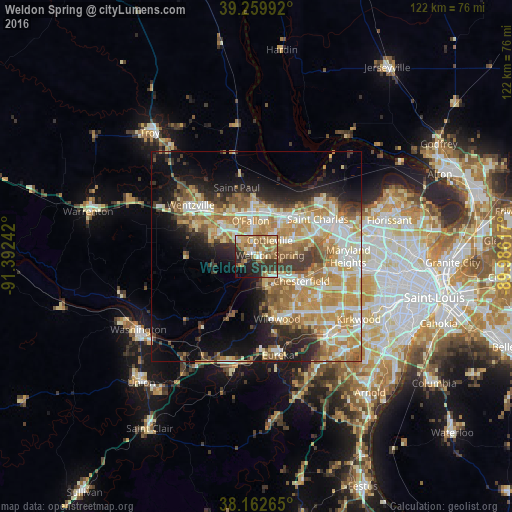
Analysis of Weldon Spring night lights 2016
Square area 10x10 km:
 5.95%
5.95%90-99
5.27%80-89
9.18%70-79
12.59%60-69
15.82%50-59
9.52%40-49
3.74%30-39
11.73%20-29
15.65%10-19
7.99%0-9
2.55%Square area 50x50 km:
6.18%90-99
6.85%80-89
5.55%70-79
8.46%60-69
7.54%50-59
4.7%40-49
3.12%30-39
4.82%20-29
6.56%10-19
10.82%0-9
35.41%Clear (daylight) street map image can be seen on geolist.org.
Map coordinates:
39° 15' 35.7" North, 91° 23' 32.7" West
38° 42' 48.2" North, 90° 41' 21.4" West
38° 9' 45.5" North, 89° 59' 10.2" West
Some cities around Weldon Spring sort by population:
• O'Fallon
10.8 km =6.7 mi,  355°
355°
• Saint Peters
11.1 km =6.9 mi,  29°
29°
• Chesterfield
11.2 km =7 mi,  119°
119°
• Wildwood
14.7 km =9.1 mi,  171°
171°
• Wentzville
17.9 km =11.1 mi,  307°
307°
• Lake Saint Louis
12.5 km =7.8 mi,  318°
318°
• Dardenne Prairie
7.1 km =4.4 mi,  331°
331°
• Ellisville
16.1 km =10 mi,  146°
146°
4413926 (p: 5,575)
Sources (retrieved 2019-11-25):
» Earth at Night: Flat Maps 2012, 2016