Tysons Corner night lights from space
Night Light of Tysons Corner (Virginia) from space (United States) Src. Average luminocity for 10x10km area is 85.2959% and for 50x50km: 74.8723%.
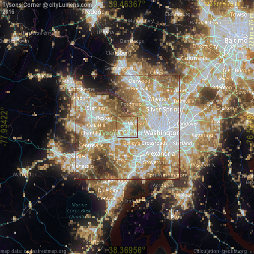
Analysis of Tysons Corner night lights 2016
Square area 10x10 km:
 25%
25%90-99
22.28%80-89
13.1%70-79
21.09%60-69
15.65%50-59
2.89%40-49
0%30-39
0%20-29
0%10-19
0%0-9
0%Square area 50x50 km:
21.74%90-99
17.76%80-89
10.02%70-79
13.28%60-69
12.49%50-59
8.53%40-49
4.6%30-39
4.1%20-29
4.18%10-19
2.04%0-9
1.26%Clear (daylight) street map image can be seen on geolist.org.
Map coordinates:
39° 27' 49.2" North, 77° 56' 3.2" West
38° 55' 7.4" North, 77° 13' 51.9" West
38° 22' 10.4" North, 76° 31' 40.7" West
Some cities around Tysons Corner sort by population:
• McLean
4.9 km =3 mi,  69°
69°
• Idylwood
3.1 km =1.9 mi,  147°
147°
• Vienna
3.5 km =2.2 mi,  236°
236°
• Wolf Trap
5.3 km =3.3 mi,  296°
296°
• Merrifield
5 km =3.1 mi,  175°
175°
• Falls Church
6.6 km =4.1 mi,  127°
127°
• Dunn Loring
2.9 km =1.8 mi,  163°
163°
• Pimmit Hills
2.7 km =1.7 mi,  103°
103°
4790534 (p: 19,627)
Sources (retrieved 2019-11-25):
» Earth at Night: Flat Maps 2012, 2016