Idylwood night lights from space
Night Light of Idylwood (Virginia) from space (United States) Src. Average luminocity for 10x10km area is 90.0493% and for 50x50km: 75.3361%.
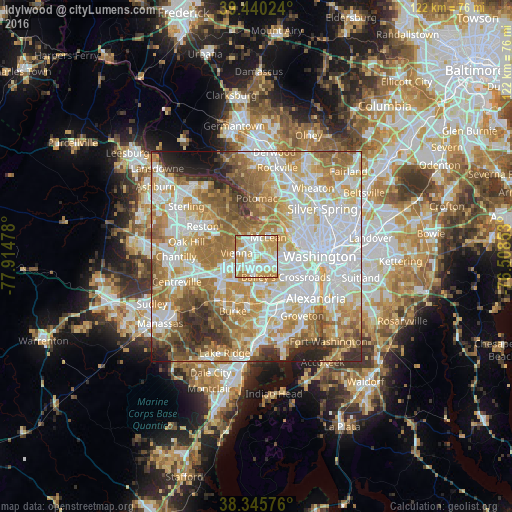
Analysis of Idylwood night lights 2016
Square area 10x10 km:
 30.95%
90-99
26.02%80-89
17.35%70-79
23.3%60-69
2.38%50-59
0%40-49
0%30-39
0%20-29
0%10-19
0%0-9
0%Square area 50x50 km:
22.23%90-99
17.9%80-89
10.28%70-79
13.16%60-69
12.2%50-59
8.18%40-49
4.62%30-39
4.02%20-29
4.78%10-19
2.03%0-9
0.6%Clear (daylight) street map image can be seen on geolist.org.
Map coordinates:
39° 26' 24.9" North, 77° 54' 53.2" West
38° 53' 42.4" North, 77° 12' 41.9" West
38° 20' 44.7" North, 76° 30' 30.7" West
Some cities around Idylwood sort by population:
• McLean
5.3 km =3.3 mi,  34°
34°
• West Falls Church
3.9 km =2.4 mi,  148°
148°
• Tysons Corner
3.1 km =1.9 mi,  327°
327°
• Vienna
4.7 km =2.9 mi,  278°
278°
• Merrifield
2.7 km =1.7 mi,  209°
209°
• Falls Church
3.8 km =2.4 mi,  112°
112°
• Dunn Loring
0.9 km =0.6 mi,  257°
257°
• Pimmit Hills
2.2 km =1.4 mi, 25°
4765553 (p: 17,288)
Sources (retrieved 2019-11-25):
» Earth at Night: Flat Maps 2012, 2016