Wolf Trap night lights from space
Night Light of Wolf Trap (Virginia) from space (United States) Src. Average luminocity for 10x10km area is 70.7058% and for 50x50km: 72.6905%.
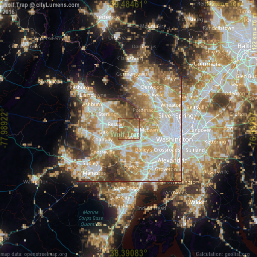
Analysis of Wolf Trap night lights 2016
Square area 10x10 km:
 9.69%
9.69%90-99
8.67%80-89
4.08%70-79
18.03%60-69
35.37%50-59
21.77%40-49
2.21%30-39
0.17%20-29
0%10-19
0%0-9
0%Square area 50x50 km:
19.82%90-99
17.38%80-89
10.16%70-79
12.91%60-69
12.29%50-59
8.37%40-49
4.46%30-39
4.81%20-29
4.83%10-19
2.72%0-9
2.25%Clear (daylight) street map image can be seen on geolist.org.
Map coordinates:
39° 29' 4.6" North, 77° 59' 21.2" West
38° 56' 23.4" North, 77° 17' 9.9" West
38° 23' 27" North, 76° 34' 58.7" West
Some cities around Wolf Trap sort by population:
• Reston
5.7 km =3.5 mi,  304°
304°
• Oakton
6.7 km =4.2 mi,  191°
191°
• Tysons Corner
5.3 km =3.3 mi,  116°
116°
• Idylwood
8.1 km =5 mi,  127°
127°
• Vienna
4.7 km =2.9 mi,  157°
157°
• Great Falls
6.5 km =4 mi,  358°
358°
• Dunn Loring
7.6 km =4.7 mi, 132°
• Pimmit Hills
8 km =5 mi,  112°
112°
4794350 (p: 16,131)
Sources (retrieved 2019-11-25):
» Earth at Night: Flat Maps 2012, 2016