Turtle Creek night lights from space
Night Light of Turtle Creek (Pennsylvania) from space (United States) Src. Average luminocity for 10x10km area is 78.9983% and for 50x50km: 51.692%.
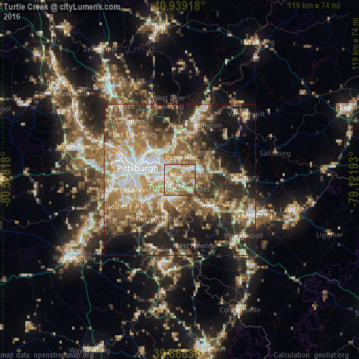
Analysis of Turtle Creek night lights 2016
Square area 10x10 km:
 15.82%
90-99
18.37%80-89
10.54%70-79
21.77%60-69
22.28%50-59
10.2%40-49
1.02%30-39
0%20-29
0%10-19
0%0-9
0%Square area 50x50 km:
8.09%90-99
9.46%80-89
6.37%70-79
7.63%60-69
10.12%50-59
10.56%40-49
8.38%30-39
7.05%20-29
11.25%10-19
12.77%0-9
8.31%Clear (daylight) street map image can be seen on geolist.org.
Map coordinates:
40° 56' 21" North, 80° 31' 41.4" West
40° 24' 21.2" North, 79° 49' 30.2" West
39° 52' 6.1" North, 79° 7' 18.9" West
Some cities around Turtle Creek sort by population:
• Monroeville
3.6 km =2.2 mi,  61°
61°
• West Mifflin
5.9 km =3.7 mi,  216°
216°
• Wilkinsburg
6.3 km =3.9 mi,  309°
309°
• Munhall
6.5 km =4 mi,  256°
256°
• North Versailles
3.2 km =2 mi,  155°
155°
• Swissvale
5.3 km =3.3 mi,  292°
292°
• Forest Hills
2.6 km =1.6 mi, 306°
• Duquesne
4 km =2.5 mi,  227°
227°
5216343 (p: 5,272)
Sources (retrieved 2019-11-25):
» Earth at Night: Flat Maps 2012, 2016