Wilkinsburg night lights from space
Night Light of Wilkinsburg (Pennsylvania) from space (United States) Src. Average luminocity for 10x10km area is 88.6344% and for 50x50km: 53.5128%.
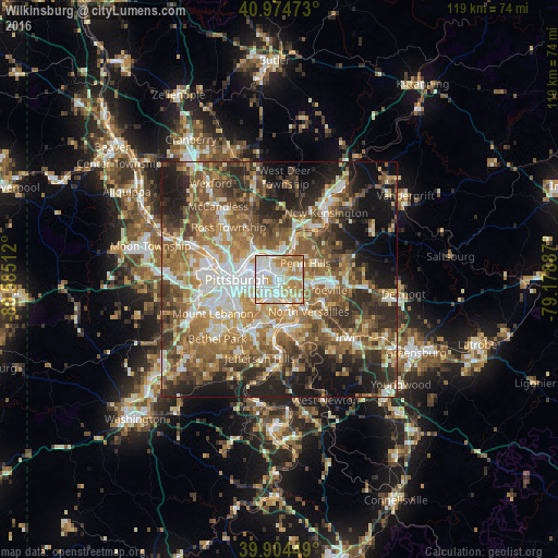
Analysis of Wilkinsburg night lights 2016
Square area 10x10 km:
 29.25%
90-99
29.42%80-89
12.07%70-79
16.67%60-69
12.59%50-59
0%40-49
0%30-39
0%20-29
0%10-19
0%0-9
0%Square area 50x50 km:
8.15%90-99
9.49%80-89
6.54%70-79
7.85%60-69
10.66%50-59
11.65%40-49
9.33%30-39
7.77%20-29
11.24%10-19
12.49%0-9
4.84%Clear (daylight) street map image can be seen on geolist.org.
Map coordinates:
40° 58' 29" North, 80° 35' 6.4" West
40° 26' 30.3" North, 79° 52' 55.2" West
39° 54' 16.2" North, 79° 10' 43.9" West
Some cities around Wilkinsburg sort by population:
• Penn Hills
7.5 km =4.7 mi,  28°
28°
• Monroeville
8.3 km =5.2 mi,  106°
106°
• Munhall
5.7 km =3.5 mi,  195°
195°
• Swissvale
2 km =1.2 mi,  182°
182°
• Forest Hills
3.6 km =2.2 mi,  132°
132°
• Duquesne
7 km =4.3 mi,  164°
164°
• Fox Chapel
8 km =5 mi,  1°
1°
• Turtle Creek
6.3 km =3.9 mi, 129°
5219501 (p: 15,731)
Sources (retrieved 2019-11-25):
» Earth at Night: Flat Maps 2012, 2016