Munhall night lights from space
Night Light of Munhall (Pennsylvania) from space (United States) Src. Average luminocity for 10x10km area is 85.8997% and for 50x50km: 53.2964%.
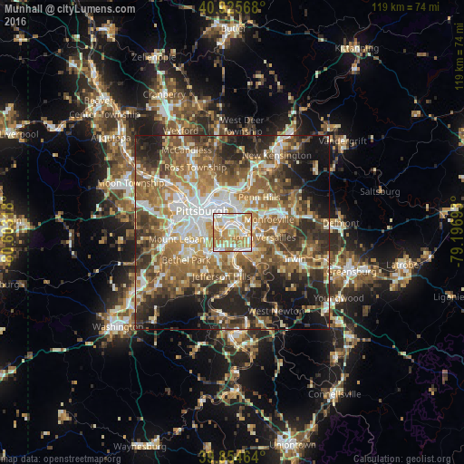
Analysis of Munhall night lights 2016
Square area 10x10 km:
 20.75%
90-99
26.19%80-89
15.31%70-79
21.09%60-69
16.67%50-59
0%40-49
0%30-39
0%20-29
0%10-19
0%0-9
0%Square area 50x50 km:
8.12%90-99
9.54%80-89
6.61%70-79
7.42%60-69
10.89%50-59
11.66%40-49
9.17%30-39
7.71%20-29
11.29%10-19
11.75%0-9
5.85%Clear (daylight) street map image can be seen on geolist.org.
Map coordinates:
40° 55' 32.4" North, 80° 36' 11.4" West
40° 23' 32.2" North, 79° 54' 0.2" West
39° 51' 16.7" North, 79° 11' 48.9" West
Some cities around Munhall sort by population:
• West Mifflin
4.3 km =2.7 mi,  138°
138°
• McKeesport
5.8 km =3.6 mi,  148°
148°
• Wilkinsburg
5.7 km =3.5 mi,  15°
15°
• Brentwood
6.8 km =4.2 mi,  249°
249°
• Swissvale
3.8 km =2.4 mi, 22°
• Forest Hills
5.2 km =3.2 mi,  54°
54°
• Duquesne
3.6 km =2.2 mi,  109°
109°
• Turtle Creek
6.5 km =4 mi,  76°
76°
5202734 (p: 11,247)
Sources (retrieved 2019-11-25):
» Earth at Night: Flat Maps 2012, 2016