North Versailles night lights from space
Night Light of North Versailles (Pennsylvania) from space (United States) Src. Average luminocity for 10x10km area is 72.0374% and for 50x50km: 49.9613%.
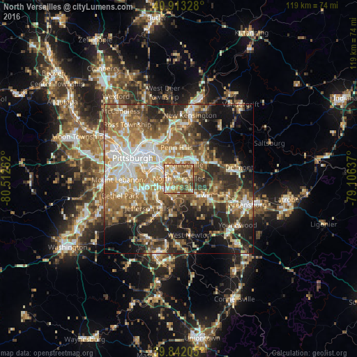
Analysis of North Versailles night lights 2016
Square area 10x10 km:
 7.99%
7.99%90-99
13.95%80-89
12.07%70-79
15.82%60-69
25.34%50-59
16.84%40-49
5.44%30-39
2.55%20-29
0%10-19
0%0-9
0%Square area 50x50 km:
7.85%90-99
9.04%80-89
6.27%70-79
7.47%60-69
9.7%50-59
9.91%40-49
7.86%30-39
6.81%20-29
11.12%10-19
12.85%0-9
11.13%Clear (daylight) street map image can be seen on geolist.org.
Map coordinates:
40° 54' 47.8" North, 80° 30' 45.4" West
40° 22' 47.2" North, 79° 48' 34.2" West
39° 50' 31.4" North, 79° 6' 22.9" West
Some cities around North Versailles sort by population:
• Monroeville
4.9 km =3 mi,  21°
21°
• West Mifflin
5.2 km =3.2 mi,  249°
249°
• McKeesport
5.8 km =3.6 mi,  232°
232°
• Munhall
7.8 km =4.8 mi,  280°
280°
• White Oak
4.7 km =2.9 mi,  179°
179°
• Forest Hills
5.6 km =3.5 mi,  322°
322°
• Duquesne
4.3 km =2.7 mi,  272°
272°
• Turtle Creek
3.2 km =2 mi,  335°
335°
5203785 (p: 10,571)
Sources (retrieved 2019-11-25):
» Earth at Night: Flat Maps 2012, 2016