Forest Hills night lights from space
Night Light of Forest Hills (Pennsylvania) from space (United States) Src. Average luminocity for 10x10km area is 83.8997% and for 50x50km: 53.0523%.
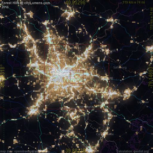
Analysis of Forest Hills night lights 2016
Square area 10x10 km:
 20.58%
90-99
25%80-89
12.24%70-79
20.58%60-69
19.56%50-59
2.04%40-49
0%30-39
0%20-29
0%10-19
0%0-9
0%Square area 50x50 km:
8.1%90-99
9.45%80-89
6.65%70-79
7.98%60-69
10.48%50-59
11.39%40-49
8.79%30-39
7.25%20-29
11.48%10-19
12.54%0-9
5.88%Clear (daylight) street map image can be seen on geolist.org.
Map coordinates:
40° 57' 10.7" North, 80° 33' 11.4" West
40° 25' 11.2" North, 79° 51' 0.2" West
39° 52' 56.5" North, 79° 8' 48.9" West
Some cities around Forest Hills sort by population:
• Monroeville
5.2 km =3.2 mi,  88°
88°
• West Mifflin
6.4 km =4 mi,  192°
192°
• Wilkinsburg
3.6 km =2.2 mi,  312°
312°
• Munhall
5.2 km =3.2 mi,  234°
234°
• North Versailles
5.6 km =3.5 mi,  142°
142°
• Swissvale
2.8 km =1.7 mi,  278°
278°
• Duquesne
4.3 km =2.7 mi, 190°
• Turtle Creek
2.6 km =1.6 mi,  126°
126°
5189981 (p: 6,443)
Sources (retrieved 2019-11-25):
» Earth at Night: Flat Maps 2012, 2016