Duquesne night lights from space
Night Light of Duquesne (Pennsylvania) from space (United States) Src. Average luminocity for 10x10km area is 81.8129% and for 50x50km: 52.4124%.
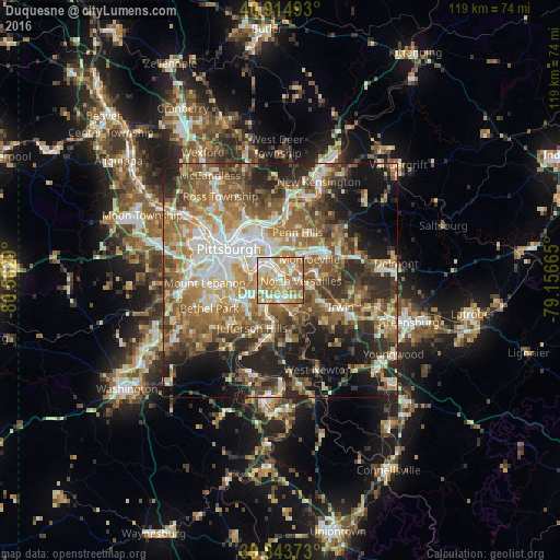
Analysis of Duquesne night lights 2016
Square area 10x10 km:
 15.82%
90-99
21.6%80-89
14.12%70-79
22.62%60-69
22.79%50-59
2.89%40-49
0.17%30-39
0%20-29
0%10-19
0%0-9
0%Square area 50x50 km:
7.94%90-99
9.44%80-89
6.73%70-79
7.77%60-69
10.48%50-59
11.21%40-49
8.65%30-39
7.07%20-29
10.79%10-19
11.9%0-9
8.01%Clear (daylight) street map image can be seen on geolist.org.
Map coordinates:
40° 54' 53.7" North, 80° 33' 46.4" West
40° 22' 53.3" North, 79° 51' 35.2" West
39° 50' 37.4" North, 79° 9' 23.9" West
Some cities around Duquesne sort by population:
• West Mifflin
2.1 km =1.3 mi,  195°
195°
• McKeesport
3.8 km =2.4 mi,  185°
185°
• Munhall
3.6 km =2.2 mi,  289°
289°
• North Versailles
4.3 km =2.7 mi,  92°
92°
• Swissvale
5.1 km =3.2 mi,  337°
337°
• White Oak
6.5 km =4 mi,  138°
138°
• Forest Hills
4.3 km =2.7 mi,  10°
10°
• Turtle Creek
4 km =2.5 mi,  47°
47°
5187580 (p: 5,535)
Sources (retrieved 2019-11-25):
» Earth at Night: Flat Maps 2012, 2016