Troy night lights from space
Night Light of Troy (Illinois) from space (United States) Src. Average luminocity for 10x10km area is 40.8299% and for 50x50km: 37.4405%.
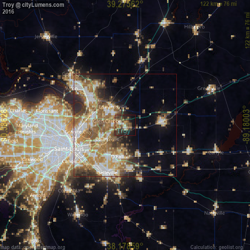
Analysis of Troy night lights 2016
Square area 10x10 km:
 2.04%
2.04%90-99
3.23%80-89
7.14%70-79
6.12%60-69
5.61%50-59
11.22%40-49
10.54%30-39
12.24%20-29
13.44%10-19
18.03%0-9
10.37%Square area 50x50 km:
6.17%90-99
7.65%80-89
5.37%70-79
5.28%60-69
7.25%50-59
6.92%40-49
4.61%30-39
4.63%20-29
5.45%10-19
6.66%0-9
40.02%Clear (daylight) street map image can be seen on geolist.org.
Map coordinates:
39° 16' 32.2" North, 90° 35' 10.6" West
38° 43' 45.2" North, 89° 52' 59.3" West
38° 10' 42.9" North, 89° 10' 48.1" West
Some cities around Troy sort by population:
• O'Fallon
15.4 km =9.6 mi,  189°
189°
• Edwardsville
11 km =6.8 mi,  326°
326°
• Collinsville
11 km =6.8 mi,  233°
233°
• Fairview Heights
18.2 km =11.3 mi,  210°
210°
• Glen Carbon
8.9 km =5.5 mi,  283°
283°
• Highland
18.4 km =11.4 mi,  86°
86°
• Maryville
6.3 km =3.9 mi,  264°
264°
• Pontoon Beach
17.1 km =10.6 mi,  270°
270°
4251513 (p: 10,036)
Sources (retrieved 2019-11-25):
» Earth at Night: Flat Maps 2012, 2016