Fairview Heights night lights from space
Night Light of Fairview Heights (Illinois) from space (United States) Src. Average luminocity for 10x10km area is 80.2484% and for 50x50km: 45.1321%.
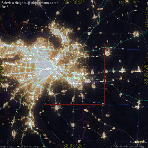
Analysis of Fairview Heights night lights 2016
Square area 10x10 km:
 14.77%
90-99
19.48%80-89
14.94%70-79
19.64%60-69
24.84%50-59
4.22%40-49
1.3%30-39
0.81%20-29
0%10-19
0%0-9
0%Square area 50x50 km:
10.1%90-99
9.11%80-89
6.14%70-79
6.46%60-69
7.56%50-59
7.09%40-49
4.78%30-39
4.9%20-29
5.76%10-19
9.53%0-9
28.57%Clear (daylight) street map image can be seen on geolist.org.
Map coordinates:
39° 8' 11.1" North, 90° 41' 36.6" West
38° 35' 20.2" North, 89° 59' 25.4" West
38° 2' 14.1" North, 89° 17' 14.1" West
Some cities around Fairview Heights sort by population:
• Belleville
7.7 km =4.8 mi,  175°
175°
• O'Fallon
6.9 km =4.3 mi,  86°
86°
• East Saint Louis
14.5 km =9 mi,  285°
285°
• Collinsville
9.1 km =5.7 mi,  3°
3°
• Swansea
6.1 km =3.8 mi, 178°
• Shiloh
8.6 km =5.3 mi,  110°
110°
• Maryville
15.3 km =9.5 mi,  11°
11°
• Centreville
11.7 km =7.3 mi,  266°
266°
4238132 (p: 16,827)
Sources (retrieved 2019-11-25):
» Earth at Night: Flat Maps 2012, 2016