Pontoon Beach night lights from space
Night Light of Pontoon Beach (Illinois) from space (United States) Src. Average luminocity for 10x10km area is 74.1616% and for 50x50km: 58.9411%.
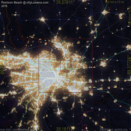
Analysis of Pontoon Beach night lights 2016
Square area 10x10 km:
 13.27%
90-99
16.33%80-89
12.24%70-79
11.39%60-69
17.18%50-59
22.28%40-49
7.31%30-39
0%20-29
0%10-19
0%0-9
0%Square area 50x50 km:
16.42%90-99
13.61%80-89
8.21%70-79
7.57%60-69
9%50-59
7.5%40-49
5.14%30-39
4.51%20-29
6.79%10-19
6.47%0-9
14.77%Clear (daylight) street map image can be seen on geolist.org.
Map coordinates:
39° 16' 41.2" North, 90° 47' 0.6" West
38° 43' 54.2" North, 90° 4' 49.4" West
38° 10' 52" North, 89° 22' 38.1" West
Some cities around Pontoon Beach sort by population:
• Granite City
6.8 km =4.2 mi,  240°
240°
• East Saint Louis
13.4 km =8.3 mi,  207°
207°
• Collinsville
10.8 km =6.7 mi,  129°
129°
• Spanish Lake
13.3 km =8.3 mi,  297°
297°
• Glen Carbon
8.6 km =5.3 mi,  77°
77°
• Bellefontaine Neighbors
12.7 km =7.9 mi,  274°
274°
• Maryville
10.8 km =6.7 mi,  94°
94°
• Glasgow Village
10.5 km =6.5 mi,  283°
283°
4247379 (p: 5,637)
Sources (retrieved 2019-11-25):
» Earth at Night: Flat Maps 2012, 2016