Glen Carbon night lights from space
Night Light of Glen Carbon (Illinois) from space (United States) Src. Average luminocity for 10x10km area is 67.8435% and for 50x50km: 46.2413%.
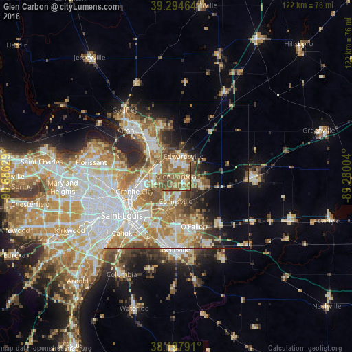
Analysis of Glen Carbon night lights 2016
Square area 10x10 km:
 5.27%
5.27%90-99
9.69%80-89
11.05%70-79
8.33%60-69
28.57%50-59
30.1%40-49
6.29%30-39
0.68%20-29
0%10-19
0%0-9
0%Square area 50x50 km:
10.39%90-99
9.52%80-89
6.49%70-79
6.81%60-69
8.35%50-59
7.17%40-49
4.63%30-39
4.25%20-29
6.26%10-19
7.1%0-9
29.05%Clear (daylight) street map image can be seen on geolist.org.
Map coordinates:
39° 17' 40.7" North, 90° 41' 10.6" West
38° 44' 54.2" North, 89° 58' 59.4" West
38° 11' 52.5" North, 89° 16' 48.1" West
Some cities around Glen Carbon sort by population:
• Granite City
15.3 km =9.5 mi,  250°
250°
• Edwardsville
7.5 km =4.7 mi,  20°
20°
• Collinsville
8.7 km =5.4 mi,  180°
180°
• Fairview Heights
17.7 km =11 mi, 182°
• Wood River
16 km =9.9 mi,  321°
321°
• Troy
8.9 km =5.5 mi,  103°
103°
• Maryville
3.6 km =2.2 mi,  139°
139°
• Pontoon Beach
8.6 km =5.3 mi,  257°
257°
4239465 (p: 12,966)
Sources (retrieved 2019-11-25):
» Earth at Night: Flat Maps 2012, 2016