Tracyton night lights from space
Night Light of Tracyton (Washington) from space (United States) Src. Average luminocity for 10x10km area is 43.267% and for 50x50km: 15.6572%.
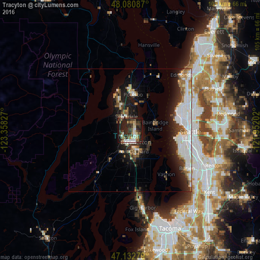
Analysis of Tracyton night lights 2016
Square area 10x10 km:
 6.39%
6.39%90-99
7.39%80-89
5.26%70-79
1.42%60-69
6.53%50-59
7.39%40-49
8.95%30-39
10.8%20-29
20.74%10-19
22.73%0-9
2.41%Square area 50x50 km:
4.42%90-99
3.4%80-89
1.23%70-79
0.94%60-69
1.66%50-59
1.49%40-49
1.77%30-39
2.13%20-29
3.88%10-19
8.15%0-9
70.93%Clear (daylight) street map image can be seen on geolist.org.
Map coordinates:
48° 4' 51.1" North, 123° 21' 29.8" West
47° 36' 32.3" North, 122° 39' 18.5" West
47° 7' 58" North, 121° 57' 7.3" West
Some cities around Tracyton sort by population:
• Bremerton
4.9 km =3 mi,  159°
159°
• Bainbridge Island
10.2 km =6.3 mi,  79°
79°
• Silverdale
4.9 km =3 mi,  323°
323°
• Port Orchard
7.8 km =4.8 mi,  169°
169°
• Parkwood
9.1 km =5.7 mi, 158°
• Bangor Trident Base
13.4 km =8.3 mi,  340°
340°
• East Port Orchard
9.8 km =6.1 mi, 166°
• Manchester
10.2 km =6.3 mi,  125°
125°
5813832 (p: 5,233)
Sources (retrieved 2019-11-25):
» Earth at Night: Flat Maps 2012, 2016