Port Orchard night lights from space
Night Light of Port Orchard (Washington) from space (United States) Src. Average luminocity for 10x10km area is 42.4247% and for 50x50km: 18.6414%.
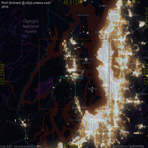
Analysis of Port Orchard night lights 2016
Square area 10x10 km:
 6.96%
6.96%90-99
9.94%80-89
2.98%70-79
3.41%60-69
5.97%50-59
6.53%40-49
7.81%30-39
5.68%20-29
14.77%10-19
25.99%0-9
9.94%Square area 50x50 km:
5.72%90-99
4.24%80-89
1.4%70-79
1.1%60-69
1.58%50-59
1.72%40-49
2.03%30-39
2.41%20-29
4.48%10-19
9.38%0-9
65.94%Clear (daylight) street map image can be seen on geolist.org.
Map coordinates:
48° 0' 46.4" North, 123° 20' 21.8" West
47° 32' 25.3" North, 122° 38' 10.5" West
47° 3' 48.8" North, 121° 55' 59.3" West
Some cities around Port Orchard sort by population:
• Bremerton
3 km =1.9 mi,  5°
5°
• Bainbridge Island
12.9 km =8 mi,  42°
42°
• Silverdale
12.4 km =7.7 mi,  339°
339°
• Parkwood
2.1 km =1.3 mi,  112°
112°
• East Port Orchard
2.1 km =1.3 mi,  154°
154°
• Manchester
7.1 km =4.4 mi,  76°
76°
• Tracyton
7.8 km =4.8 mi,  349°
349°
• Maplewood
16.5 km =10.3 mi,  158°
158°
5807236 (p: 13,607)
Sources (retrieved 2019-11-25):
» Earth at Night: Flat Maps 2012, 2016