East Port Orchard night lights from space
Night Light of East Port Orchard (Washington) from space (United States) Src. Average luminocity for 10x10km area is 33.2372% and for 50x50km: 20.1715%.
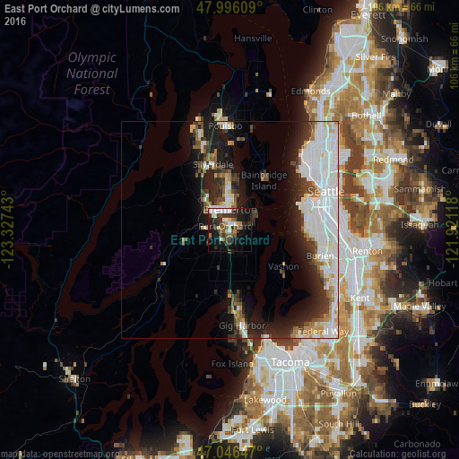
Analysis of East Port Orchard night lights 2016
Square area 10x10 km:
 4.55%
4.55%90-99
7.67%80-89
1.85%70-79
2.56%60-69
3.69%50-59
4.4%40-49
6.82%30-39
5.68%20-29
13.78%10-19
23.86%0-9
25.14%Square area 50x50 km:
6.41%90-99
4.79%80-89
1.49%70-79
1.24%60-69
1.66%50-59
1.65%40-49
2.06%30-39
2.55%20-29
4.97%10-19
9.03%0-9
64.16%Clear (daylight) street map image can be seen on geolist.org.
Map coordinates:
47° 59' 45.9" North, 123° 19' 38.7" West
47° 31' 24.3" North, 122° 37' 27.5" West
47° 2' 47.3" North, 121° 55' 16.2" West
Some cities around East Port Orchard sort by population:
• Bremerton
4.9 km =3 mi,  352°
352°
• Bainbridge Island
13.8 km =8.6 mi,  34°
34°
• Silverdale
14.5 km =9 mi,  338°
338°
• Port Orchard
2.1 km =1.3 mi,  334°
334°
• Parkwood
1.5 km =0.9 mi,  44°
44°
• Manchester
6.9 km =4.3 mi,  58°
58°
• Tracyton
9.8 km =6.1 mi, 346°
• Maplewood
14.4 km =8.9 mi,  159°
159°
5793237 (p: 5,919)
Sources (retrieved 2019-11-25):
» Earth at Night: Flat Maps 2012, 2016