Bainbridge Island night lights from space
Night Light of Bainbridge Island (Washington) from space (United States) Src. Average luminocity for 10x10km area is 4.0982% and for 50x50km: 31.6834%.

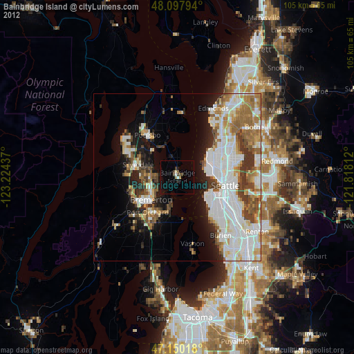
Analysis of Bainbridge Island night lights 2016
Square area 10x10 km:
 0%
0%90-99
0%80-89
0%70-79
0.6%60-69
0%50-59
0.15%40-49
2.83%30-39
0.6%20-29
0%10-19
3.87%0-9
91.96%Square area 50x50 km:
9.99%90-99
7.83%80-89
2.54%70-79
3.13%60-69
4.22%50-59
2.7%40-49
3.37%30-39
3.33%20-29
3.83%10-19
8.1%0-9
50.95%Clear (daylight) street map image can be seen on geolist.org.
Map coordinates:
48° 5' 52.6" North, 123° 13' 27.7" West
47° 37' 34.4" North, 122° 31' 16.5" West
47° 9' 0.6" North, 121° 49' 5.2" West
Some cities around Bainbridge Island sort by population:
• Seattle
14.4 km =8.9 mi,  98°
98°
• Bremerton
10.6 km =6.6 mi,  231°
231°
• Silverdale
13.2 km =8.2 mi,  278°
278°
• Port Orchard
12.9 km =8 mi,  222°
222°
• Parkwood
12.3 km =7.6 mi,  212°
212°
• East Port Orchard
13.8 km =8.6 mi, 214°
• Manchester
8 km =5 mi,  192°
192°
• Tracyton
10.2 km =6.3 mi,  259°
259°
5816320 (p: 23,840)
Sources (retrieved 2019-11-25):
» Earth at Night: Flat Maps 2012, 2016