Manchester night lights from space
Night Light of Manchester (Washington) from space (United States) Src. Average luminocity for 10x10km area is 11.25% and for 50x50km: 28.3906%.
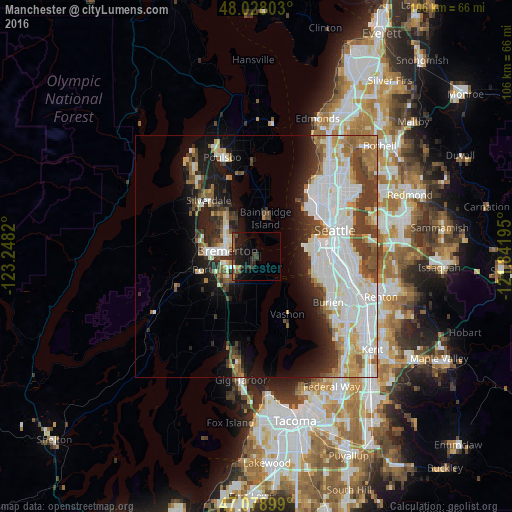
Analysis of Manchester night lights 2016
Square area 10x10 km:
 0.14%
0.14%90-99
0.43%80-89
0%70-79
1.14%60-69
1.7%50-59
2.41%40-49
2.98%30-39
2.41%20-29
8.81%10-19
14.77%0-9
65.2%Square area 50x50 km:
8.99%90-99
6.78%80-89
2.13%70-79
2.4%60-69
2.98%50-59
2.75%40-49
3.37%30-39
3.62%20-29
4.32%10-19
8.91%0-9
53.75%Clear (daylight) street map image can be seen on geolist.org.
Map coordinates:
48° 1' 40.9" North, 123° 14' 53.5" West
47° 33' 20.4" North, 122° 32' 42.3" West
47° 4' 44.4" North, 121° 50' 31" West
Some cities around Manchester sort by population:
• Bremerton
6.7 km =4.2 mi,  281°
281°
• Bainbridge Island
8 km =5 mi,  12°
12°
• Port Orchard
7.1 km =4.4 mi,  256°
256°
• White Center
14.9 km =9.3 mi,  106°
106°
• Vashon
13.6 km =8.5 mi,  152°
152°
• Parkwood
5.5 km =3.4 mi,  242°
242°
• East Port Orchard
6.9 km =4.3 mi, 238°
• Tracyton
10.2 km =6.3 mi,  305°
305°
5802247 (p: 5,413)
Sources (retrieved 2019-11-25):
» Earth at Night: Flat Maps 2012, 2016